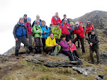
Ramblers in Glendalough - Sept `24
For our September trip this year the club headed back to Glendalough. The Saturday looked promising weather wise so we went ahead with our planned treks - the A group doing a north to south traverse of the sinuous Scarr-Brown Mountain-Paddock Hill Ridge between Lough Dan and Glendalough, while the B group followed a section of Saint Kevin`s Way through the Vale of Glendasan, finishing in Glendalough, and visiting some old mining locations en route. On Sunday we did a way-marked loop through the wooded hills of Derrybawn Mountain.
 |
| Mining Site in Glendasan on St Kevin`s Way Walk |
Ramblers in Sneem - April `24
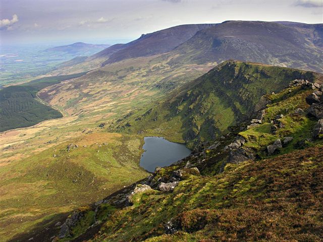
It had been a while since we walked in Iveragh so the decision was made to do so for our Spring break. On Saturday the A Walk, led by a local guide, did a grand mountain trek via Eagle Lough to Coomnacronia, Knockmoyle and Knocknagantee. The B group headed off to Caherdaniel to do a leg of the Kerry Way, the highlight of which was the magnificent Staigue Fort. On Sunday we stayed local and did the way-marked Lomanagh Loop.
 |
| Above Eagle Lough with Knocknagantee behind |
Ramblers re-visit the Mournes - Sept `23
Hard to believe it`s over 10 years since we visited the Mournes. Last time the visit clashed with an All Ireland Hurling Final, so our numbers were as low as 6! This time, no such problem. On Saturday we did a linear walk, with higher and lower options, from Trassey Bridge car park north of Hare`Gap to Newcastle, with the out and back trek to Slieve Donard a must do. On Sunday, with iffy weather, we satisfied ourselves with a coastal walk in the Murlough Nature Reserve just north of Newcastle.
 |
| Beside the Mourne Wall with Slieve Bearnagh and Meelmore behind |
Ramblers on Achill - April `23
It`s a long way from Carrick-on-Suir to Achill, Ireland`s largest island, so the club decided to stay an extra night. Unfortunately the weather didn`t play ball on the Saturday so we had to cancel the A Walk to Croughaun and its majestic cliffs. The B Walk took us up Slievemore, with the haunting deserted village at its foot. On Sunday the weather again caused a change of plan, too windy for the Minaun Cliffs, so the group ventured on the way-marked Paul Henry Loop, part of if along the scenic coastline. On Monday the committed siúlóirí, who were staying the extra night, enjoyed the grand Gráinne Mhaol Walk on the east side of the island.
 |
Slievemore Summit
|
Ramblers on the Dingle Peninsula - Sept `22
In September, for "Our Day Out" we decided to make a weekend of it and a good crowd headed for the Dingle Peninsula. This time the whole group partook in the same walk on Saturday, a linear walk north of Mount Brandon over Másatiompán and finishing near Brandon Point. The highlight of the walk was probably stunning Sás Creek with its vertiginous views. On Sunday a more leisurely stroll was organized for Magherees Beach near Castlegregory.
 |
Dramatic Sás Creek near Brandon Point |
Ramblers back in Snowdonia - June `22
After the terrible years of Covid, it was great to be able to travel overseas again. We decided to take the ferry to the nearby destination of Snowdonia,, basing ourselves in Betws Y Coed. Many of our members hadn`t climbed Mount Snowdon so that was a priority. The weather obliged on Day 1, so mission accomplished via the Pyg Track. The second day saw us travel along the picturesque Slate Trail from Capel Curig to Swallow Falls. On Day 3 we visited the spectacular glacial valley of Nant Ffrancon and did a walk which took in Llyn Ogwen, Llyn Idwal and Bwlch Tryfan.
 |
| At Bwlch Moch with Llyn Llydaw on left and Mt Snowdon on right |
Ramblers in Connemara - April `22
After a few years in dock because of Covid 19, the club got back to some away trips in 2022. For our Spring Weekend Away we headed for Leenane and got lucky with the weather!
 |
Approaching Maumturkmore with Inagh Vaaley below |
On Saturday a good crew took on a 6 hour plus hike on the Maumturks, while the slightly more sensible cohort did a grand walk along Killary Harbour. On Sunday we climbed Binn Shléibhe near Lough Mask.
Ramblers in Nerja - May `19
This year we decided that we would head to
the sun for our overseas trip. Nerja was the destination for the seventeen
members who travelled and Vernon put some great preparation into the trip.
Himself and Emily did the leading.
The first three days saw us trek to places
like the Cruz de Pinto, the Cruz de Felix, the valley of the
 |
| At Cruz de Pinto |
Higeuron, the Mediterranean "white villages" of Frigiliana and Maro, the Shadow of the Wolf (at 800 metres, thr highest point reached during the week) and Rufino`s Cottage,
Acebuchal (known as "the Hidden Village") with its tragic association with the Spanish Civil War. The weather was hot
but sure the views were great!
Day 4 was a rest day. Some decided to visit
the caves of Maro, some went shopping and an intrepid group of 6 went kayaking
near the sea caves. The second last walk involved a trek from Maro to
Frigiliana via the Pinarillo Track and Barranco de Coladillas and Chillar River.
 |
| Ice Cream time in Nerja |
The final seven kilometre unshaded trek to Frigilliana made some of us wonder why
didn`t we take the bus? The last walk was a coastal walk of sorts, from Herradura
to Playa Cantijirian, ending with lunch in a chiringuito (beach bar). A
fitting end to a great week!
Ramblers on the Sheep`s Head - April `19
For the second year in a row bad weather
put a damper on our spring weekend away.
 |
| Gougane Barra |
Our planned Sunday walk which involved
following the St. Finbarr Pilgrim Path over the Sheehy Mountains down into
Gougane Barra had to be cancelled due to the wind and rain. Instead six hardy
souls rambled around the woods for a couple of hours.
Our Saturday walk on the Sheep`s Head went
ahead thankfully. Twenty four of us started out from the Black Gate car park at
10.00 and made our way up onto the low ridge that dominates the peninsula. Visibility
wasn`t great and the winds were strong enough but thankfully the rain held off as
we passed Cahurlagh Marriage Stone, Laharanmhadra Lough, a Napoleonic signal
tower, Doo Lough, a second world war lookout shelter, Lough Akeen.
 |
| Descending to Laharanmhadra Lough |
Bernie`s Cupán
Tae provided some welcome respite before we headed for the Light House at the
western tip of Sheep`s Head.
With the weather forecast in mind, a chat was
needed at this stage and this brought a group decision to plough on and complete
the intended walk. We took a second lunch in a reasonably sheltered spot above
Foilemore Cliffs. From here we continued eastward along the northern side of
the peninsula with nary a glimpse of Béara across the gloom of Bantry Bay. On
reaching the dramatic Eskraha sea fissures the weather worsened and we got
seriously drenched over the last four kilometres as we made our way up from The
Cove over the “sting in the tail” central spine to return to the sanctuary of
the bus at the Black Gate.
The club`s second trip to Cumbria`s Lake
District proved to be a bit of a sizzling experience! With temperatures in the
high twenties three walks in three days set us a serious challenge. Thankfully
Ambleside worked out to be a very suitable base, with its proximity to
Wordsworth country and the stunning Langdale Valley.
The key aim for most of the group was to do
Scafell Pike, England`s highest mountain.
 |
| Scafell Pike summit in sunshine |
Accordingly, we decided to tackle it
on day one, doing a south to north traverse, starting at Dungeon Ghyll in
Langdale and finishing at Seathwaite Farm in Borrowdale. Sixteen of us used
plenty of water and sun cream to help us survive in the heat for 8 hours! The
highlight of the walk for some had nothing to do with the stunning views,
rather the cool waters of Angle and Styhead Tarns. As one member put it, it was
the first time that he had two swims on the one walk.
Day two saw twenty of us do the “Wordsworth
Walk” – a leisurely lakeside ramble from Ambleside to Grasmere, following the
old Coffin Trail to the east of Rydal Water and Lake Grasmere on the way out
and the lower slopes of Loughrigg Fell on the way back.
 |
| Resting by Lake Grasmere |
A visit to Wordsworth`s
grave in Grasmere was obligatory while a visit to one of the poet`s homes at
Dove Cottage inspired a recital of some of his poetry by two of our more
“cultured” members.
By day three we had only seven “real”
walkers left, the more sensible ones heading for a boat trip on Lake
Windermere. Off with us seven to do Crinkle Crags in Langdale. This proved a
very interesting walk with a little bit of scrambling thrown in just to make us
feel even more wrecked. One of the highlights was undoubtedly Josh`s impressive
negotiation of the “Bad Step” to reach the summit of the second Crinkle. There
was a little “debate” on the identity of a distant lake. In light of the
absence of conclusive proof we decided that we had discovered a new lake and
the witty Sasanach in our midst felt we should call it “Mick`s Mere”.
Eventually it was time to return home, and even
though the attempt at a sing song on the last night could have been better,
most would agree that we had just had a very memorable trip.
Twenty four of us turned up on Saturday
morning for the planned challenging linear walk along the Caher Ridge to Carrauntoohil.
Because of the large numbers we decided to divide up into two groups consisting
of 16 hardy annuals and eight half-hardy ones. Both groups started from the
Hydro Road car park near Lough Acoose. The first two hours involved a lot of
hard work as we climbed up the southern shoulder of the beautiful Coumloughra
glen with its ribbon lakes. Behind us to the north the views to the north and
west expanded as we gained height – Dingle Bay and the mountains of Dingle
Peninsula, Inch Strand, Glenbeigh, Lough Caragh.
When we reached Caher West at 975 metres
elevation, we had reached the Caher Ridge proper. From here the ridge first
trended east then north east for the final pull up to Carrauntoohil. The
weather
 |
| On Caher Ridge |
while dry with good if intermittent visibility, was now posing a
serious problem because of strong winds and dangerous gusts. Down to our right
lay the Bridia and Black Valleys with lovely lakes like Curraghmore and
Cummeenduff Loughs. Beyond them lay the sea of mountains that populate the
Iveragh Peninsula. We could make out the towering Bruaghnabinnia, Knockaunattin
and Mullaghanattin, “the Kerry Matterhorn”. Unfortunately, we could devote
little time to the beauty before us as all our attention was needed to make our
way safely across the arete`s narrow rocky path in the dangerous windy
conditions.
After lunch on the roof of Ireland we faced
 |
| Descending the Devil`s Ladder |
another daunting challenge – the descent down the 300 metres high Devil`s
Ladder. The lower third was especially iffy as a lot of the scree and boulders
here were wet. The final trek through the Hag`s Glen between Loughs Gouragh and
Callee and alongside the Gadagh stream was uneventful and soon our destination
in Cronin`s Yard was reached. Here the hardy annuals enjoyed a cuppa while they
waited for the half-hardy ones who were enjoying a couple of torrential showers
over the last half an hour or so!
On Sunday the intention was to do Torc
Mountain. However, the exertions of Saturday together with the forecast of
heavy showers put paid to that. The resultant change of plan led to a walk akin
to one devised by a committee i.e. it was democratically arrived at, had plenty
input, had the odd mistake, and took longer to complete than originally
intended! Still, the result wasn`t half bad and we even discovered Cardiac Hill
on the northern flanks of Torc Mountain, although we didn`t count the steps!
It had to happen eventually, I suppose. Our
hill walking holidays have been blessed with good weather for years now. Not
this trip to the Dolomites in northern Italy in late June however – we had
thunder and lightning and spells of heavy rain every day except one!
We were based in the village of Madonna Di
Campiglio, nestling at 1550 metres altitude in
the Val Rendena between the granite mountains of Presanella to the west and the
dolomitic limestones of the Brenta Dolomites to the east. Over the week under
the care of our excellent guide Nicole we did five walks but these were
 |
| Top of 5 Laghi Gondola |
chopped
and changed on occasion because of the weather e.g. the attractive Giro di 5
Laghi and high Brenta Hut walks were shelved. The Presanella Range
has many lakes and we trekked to just two of them – Nambino and Ritorto (a
majestic coum and lake). We visited the impressive Vallesinella
Falls in the Brenta Mountains
on two occasions. The hillsides were adorned with attractive open woodland and malgas
(meadows grazed by animals on alps or mountain benches).
The highlight for everyone probably
happened on Thursday. Six adrenaline junkies opted to do a via ferrata near
Rifugio Tuckett in the Brenta Mountains and they are still talking about it
(and the ladies are still talking about the guide as well)!
 |
| Via Ferrata Team |
The rest of us
enjoyed a lovely high level walk on the limestone/dolomite plateau between
Passo Grosté and Rifugio Tuckett and from there on to Rifugio Casenei. The
variety of plant and flower amongst the limestone pavement was amazing –
arnica, sea pink, gentian, delicate edelweiss, veronica etc.
It wasn`t all walking for the week. There
was the good grub in the hotel and also in the refugios, the visits to the
Dolomiti pub, the trip to Lake Garda, and of
course the shopping!
Ramblers in Westport - Spring 2017
Mweelrea is a grand mountain. At 814 metres in elevation it is Connaught`s highest and the club`s number one priority on our recent weekend away in Westport. The other provincial tops of Corrauntoohil, Lugnaquilla and Slieve Donard had already been visited so it was about time we climbed Mayo`s finest.
Starting at Delphi Adventure Centre we decided on a clockwise circuit.
 |
| On the final climb to Mweelrea |
Good if hazy views of Killary Harbour, the Twelve Bens and Maumturks appeared as we ascended, with Inisbofin and Clare Island beckoning from a calm sea. After a leisurely lunch on Mweelrea we took a sneaky line on the descent, contouring north-eastward under the shoulder of Ben Bury and avoiding its summit! The Ben Lugmore arête provided fine walking with the cliffs of Com Dubh and Doo Lough on our left and Bellewaum corrie on our right. After 7 hours and 16 kilometres trekking it was mission accomplished!
We did two other walks over the weekend. On Saturday some members decided on the easier option of the Keenagh Loop in the Nephins. Reports coming back mentioned splendid views of Clew Bay and Beltra Lough, the many serene small lakes, and of course the climb of Knockaffertagh!
 |
| Knockaffertagh Panorama |
We couldn`t return home on Sunday without climbing Croagh Patrick. 15 members embarked on the long trudge. Hard to believe that the vast majority had never visited Ireland`s Holy Mountain before. The scree and steep ground proved challenging for some but the job was eventually done!
Ramblers in the Tirol – June`16
Sunday June 26th and off with 23 of us on our trip to the Austrian Tirol. “Not an auspicious start” we were thinking as we stepped off the bus in Fussen to visit Neuschwanstein Castle. It was bucketing down and we couldn`t even see the “sleeping beauty” castle never mind visit it! Thankfully things picked up when we reached our Topflight hotel Sonnenburg in Ehrwald to be greeted by our friendly hostess, Daniela. Thankfully as well, our Korean traveller John Mac had arrived safe and sound. Luckily for John our chair Emily had carried his boots for him, otherwise he mightn`t have been able to do much walking!
Next morning, Monday, we met our witty and knowledgeable guides Martin and Reini and they outlined the rough schedule for the week. As it turned out the weather was quite good, dry and bright most of the time with a couple of evening thunder storms. Monday`s walk was to be an introductory one as we headed south to the bottom of the Seebenbach waterfall which plunges over the cliffs of the very impressive Sonnenspitze.
 |
| Walking the high meadows under Sonnenspitze |
As we walked along Reini explained how the “wellie”(valley!) of the Zugspitze Arena was formed after the retreat of the last glaciers 5000 years ago. Next it was on to the base station of the Ehrwalder Almbahn where we purchased our Z-Tickets. These gave us good value on the cable cars, fine swimming pool in Ehrwald, other attractions in the area etc. After a leisurely bite to eat at the Ehrwalder Alm hut it was time for our first gondola trip – to the top of the Ehrwalder Almbahn. Here a few members felt like a more strenuous workout and climbed the Issentalkopft on the southern slopes of the Wetterstein Mountains. The rest of us followed the leaders to the lovely Ehrwalder Alm reservoir and then down slope back to base.
The rest of the week passed in a blur of activity, people doing their own thing at times. There were trips to Munich on the little red train, shopping in pretty Garmisch, a visit to the “High Line” bridge near Heiterwang (incidentally, a new company – D and E Tours was announced on this trip), a cruise on Heiterwangsee and Plantsee, mountain biking across the Moos between Ehrwald and Lermoos, a gondola trip to the interesting Grubigstein Mountain etc. etc. The nights were passed against the backdrop of the European Championship. After a fine dinner in the Sonnenburg we would invariably retreat to the bar to watch the "exciting fare".
Then of course there were the walks. On Tuesday we headed for the hanging valley high up on the Sonnenspitze. Here on the mountain`s eastern flanks glaciers have cut serious valleys at different levels. These are occupied by lakes Seebensee (achingly beautiful) and higher up Drachensee.
 |
| Turquoise Tranquility of Seebensee |
The Coburger Hut at 1900 metres offered us some fine vistas as well as much needed sustenance. On Wednesday we “did” Gruner Ups on the flank of Daniel Mountain to the north-west of Ehrwald. Again it was “alpine pace”. Not sure we`re all in favour! Some of us could do with a few more stops on the steep ground! The highlight was probably the viewing platform at the Tuftlalm with great views of the Zugspitze Arena`s villages and valleys. On Thursday it was off north to the Zugspitzebahn base station. A walk ensued which finally brought us south along the Hohenweg to Gamsalm and eventually Ehrwald.
For many Friday was the highlight of our trip – a visit across the border to the Zugspitze, at 2962 metres the highest mountain in Germany. The 10 minute cable car ride on the “Tiroler Zugspitzbahn” was spectacular enough but what lay in store above was even more jaw-dropping – mountains as far as the eye could see in all directions. Only one member, Aidan, ventured on the walk down from the summit, the warning of our guides putting most of us off. Aidan`s report back made some of us regret not taking up the challenge. Saturday was a day off and we did our own thing, some of us with sore heads after Friday night`s sing-song with Seán leading the way. On Sunday it was time to say goodbye to Ehrwald and thank our gracious hosts, Daniela and Mido, after a memorable week.
Ramblers in Béara Spring 2016
Last year it was Donegal, this year the Béara Peninsula.
And still the good weather followed us! One of these years… Twenty one did the
trip, basing ourselves in Kenmare.
 |
| Above Cummeengeera |
On Saturday we decided to do two walks. The
first of these took on the challenging Cummeengeera Horseshoe near Lauragh.
Eleven of us met at Shronebirrane
Stone Circle where we commenced our trek with an
arduous steep wet ascent of the eastern slopes of Lackabane. The final descent
down Shronebirrane six hours later was equally steep and damp! In between
however we enjoyed some fine walking along the ridge encircling Cummeengeera Valley,
trekking from Lackabane to Eskatarriff to Coomcloghane to Tooth Mountain
to Shronebirrane. Views were great in all directions notably towards Hungry
Hill to the south and across Kenmare Ria to the McGillycuddy`s Reeks and the
Skelligs to the north and north-west. The only problem encountered seemed to be
how many tea breaks we should have. Maybe we should set up a sub-committee to
examine this issue!
 |
| The amazing colours of Coomerkane Valley |
The second Saturday walk was a more sedate
affair. The motley crew of six was comprised of three recuperators (is that a
word?), two nurses (to mind them?) and one almost senior citizen (to lead
them?). We headed for the historic valley
of Coomerkane near
Glengarriff from where Donal Cam O`Sullivan Béara led 1000 of his people to
Leitrim in January 1603. An enjoyable walk saw us visit lovely lakes like Barley Lake,
Lough Dereenadavodia and Lough Eskahooleaghaun and cross Crossterry and Dereenboy
Ridges before finishing in Derrynafulla oak woods.
As usual we hadn`t as many takers for
Sunday`s walk. The exertions of Saturday meant a change of plan – a leisurely
scenic walk along the Old Kenmare
Road as far as Torc Waterfall. All we needed to do
after that was to bring the good weather home with us!
Ramblers on Mangerton July 2015
Eventually we got to it! Mangerton, the highest mountain in Killarney National Park. We`ve been talking about doing it for three years and on Saturday July 25th last twelve of us finally tackled the "Deceiver" and added the Horses` Glen for good measure. We weren`t disappointed either on one of the driest clearest days of a poor summer. It took us 6 hours but well worth it it certainly was!
Starting at Gortgullane a few kilometres outside Killarney we began the trek by making our way up an old Victorian pony track to the Devil`s Punchbowl. From this scenic corrie lake, after a "sos beag" and time to
 |
| Gang at the Devil`s Punchbowl |
drink in the views down to Killarney town and across Lough Leane to Purple Mountain and the McGillycuddy`s Reeks, it was onward to Mangerton summit and after that the beginning of the Horses` Glen, a dramatic 5 kilometre long glacial trench floored by three ribbon lakes - loughs Erhiogh, Managh and Garagarry. We followed the rim of the L-shaped glaciated valley with a magnificent "sos mór" stop above Lough Managh. From here we ploughed ahead over Stoompa Mountain, finally descending the spur close to Lough Garagarry. All that was left now was to cross the Owengarriff River and a "boggy bit" before rejoining the pony track and eventually reaching the cars, a tired but elated group.
Ramblers “on the hills of Donegal” Spring 2015
On April 17th last seventeen of us took the long road north to Donegal for the club`s annual spring weekend away. Again, the weather had to be seen to be believed – wall to wall sunshine on both days! Despite having a few mishaps over the weekend – a minor injury, an eye infection, a bout of illness – most will probably agree that the trip was a memorable experience.
 |
| Bunglas Viewing Point Slieve League |
On Saturday we climbed Slieve League (Sliabh Liag-“the mountain of the flagstones”). The cliffs of Slieve League are Ireland`s highest, almost three times as high as the Cliffs of Moher. Starting at Bunglas viewing point, we made our way uphill past Scregeighter and Keeringear cliffs before crossing the narrow “One Man`s Pass” to reach the summit of 595 metres. After an idyllic lunch perched high above Donegal Bay we followed a pilgrim path back to the cars (this path is believed to be associated with Saint Assicus, a follower of Saint Patrick).
On Sunday our destination was Errigal, Donegal`s highest mountain at 751 metres. Errigal means sanctuary and was visited frequently by Saint Adamnan, biographer of Saint Columkille, patron saint of Donegal.This
quartzite massif on a bright day provides vistas hard to match anywhere in Ireland. We began our ascent with a “detour” to Errigal`s easterly satellite, Mackoght. From it`s top we could see the other mountains of the “Joey Glover Highlander” challenge walk – Muckish, Aghla Beg, Aghla Mór, and of course the beautiful Altan Lough. Next we girded our loins, dropped down to the col, and headed for Errigal itself. One member almost went on strike on the steep ground here but changed her mind and forged ahead! The narrow arête between Errigal`s twin summits gave us a fabulous panorama of north-west Donegal – the coastline of Bloody Foreland and Tory Island to the north, Loughs Dunlewy and Nacung as well as the Poisoned Glen and Slieve Snaght to the south. Over a leisurely lunch two “ladies” were seen squaring up to each other in Waterford and Tipp jerseys but thankfully peace broke out in the end! Eventually we headed down to the cars where Máiréad`s day was made when she met her Gaeltacht Irish speaking cousin!
Ramblers on the Mournes Sept `14
Not too many members headed north for the Mountains of Mourne trip recently. In late June it looked like we`d have fourteen or fifteen, by mid September it was down to six! Still, an enjoyable if energetic weekend was had by “all” with the weather playing ball and with nothing untoward to report except for the fact that our female members were seen on the night of the big match chatting up two Down lads who were shouting for Kilkenny!
On Saturday we took a taxi to Trassey Track, the starting point for a west-east traverse of some of the
 |
| M and M on Slievenaglogh, Ben Crom Reservoir behind |
highest peaks in the Mournes – Slievenaglogh, Slieve Commedagh and Slieve Donard – finishing at the bottom of the Glen River Valley at Newcastle. The trek took almost six hours with grand views throughout – the high peaks, the reservoirs, the Mourne Wall, Dundrum Bay etc.
On Sunday we drove to the Silent Valley Mountain Park. First up we trekked along the side of the Silent Valley Reservoir with Doan and Ben Crom dominating the skyline ahead. When we reached the Ben Crom Reservoir it was upward onto the Binnian Ridge. The vistas back down over the reservoirs and across to Slieve Bearnagh were breath taking and we passed some interesting granite blocks (tors) standing like Easter Island statues on the ridge. Some intermittent cloud grabbed our attention as we lunched on Sliev Binnian. Next came the tricky bit – finding the wall and descending the very steep slope via Wee Binnian to the sanctuary of the car park!
Ramblers in Scotland - June 2014
This year we decided to finish the "set" and "do" Ben Nevis. So off with us, sixteen members and four “guests”, to Fort William on the last week of the month. And, believe it or not, we had great walking weather, dry and not too hot with glorious visibility. The result was a feast for the senses – fabulous scenery
in Britain`s most mountainous area.
Eighteen of us climbed the Ben by the “Pony Track” on day 1 – a seven
hour and fourteen kilometres unforgiving and unrelenting trudge on a
hard rocky path out and back to the roof of Britain. A few of our
 |
| Mick, Maura and Eileen on Ben Nevis snowfield |
members found the route “directionally challenging” and didn`t arrive
back at the correct “base camp”. One member`s explanation was that “real
men don`t ask for directions”. Another member`s wife said that she was
tempted to buy her husband a tee-shirt which read “Don`t follow me, I`m
lost”. The “patient” (???) leader and a few more of us even managed to
miss the bus back to Fort William!
Day 2 involved an easier walk along the West Highland Way from The White
Corries Ski Station to Kinlochleven. Eleven of us (some of the rest
went on a trip on a steam train) started out at the jaw-dropping
spectacular entrance to Glencoe Valley. We passed by the dramatic
Buachaill Etive Mór that we would be climbing the following day, before
ascending the “Devil`s Staircase” and then descending into glaciated
Glenleven with the very scenic Mamores as a backdrop. This time we did
manage to make the bus, but only just!
Day 3 saw us tackle the Buachaill Etive Mór Ridge in the heart of stunning Glencoe. Irene led a group of twelve from Ailtnafeadh, up into Coire na Tulach (where one female member decided to “frisk” an Australian walker) and from there onto the main ridge. We visited two Munros (mountains above 3000 feet or 915 metres), the first one, Stob Dearg, being the ridge`s highest at 1022 metres. From here the panorama was majestic. Some of the highlights included – to the east Rannoch Moor, to the north the unusual shape of Ben Nevis and the Carn Mór Dearg, and the Buachaill Etive Beag and Aonach Eagach ridges. After lunching on the summit it was downward and then upward to Stob na Doire (another Munro) before descending into
Lairig Gartain and following the Coupall River back to our starting point. A great mountain day.
Thankfully most people really enjoyed our trip to Scotland. One of the
highlights was undoubtedly the last night in the Clan MacDuff Hotel. As
usual the compliments were flying. You wouldn`t want to be sensitive
with this lot! And for once the singing was even bearable with Marie,
Mari and Jacqui leading the way. A few presentations were made but none
was made to the “fab 6”- the members who completed all three walks –
Irene, Naomi, Tony, Maura, Emily and Mick. I think there should have
been, I really do! It was a
pity we had to return home at 8 the
following morning.
Ramblers visit Connemara - Spring 2014
This year Clifden was the destination for our spring walking weekend. Again the usual pattern was followed
– a long walk on Saturday with a short jaunt on
Sunday morning. This time members could choose between the Glencorbet
Horseshoe (7 hours plus) and a section of the Western Way from Gleninagh
to Leenane (4 hours plus) for their Saturday fix. And thankfully,
despite some early morning cloud and rain, both groups enjoyed glorious
views of the Twelve Bens and the Maumturks, as the weather improved
tremendously from mid morning.
 |
| Ann, Máiréad, Eileen, Denise with Killary Harbour behind |
The “high” walkers wondered how many Bens
we might manage before we were hit by “the bends” from all this upping
and downing from Ben to col to Ben to col etc. In the end it was 3.5!
First up we almost climbed Maolán before Benbrack, Benfree and Benbaun
(highest of the Bens at 729 metres) were negotiated. All the time we had
fine views of some other Bens and down into the glaciated valleys of
Glencorbet, Gleninagh and Owenglin. The final descent off Pashemore
Ridge on screes and wet slippery rock took a little time and some toll
on some knees and other body parts!
The “low” walkers for their part enjoyed a ramble underneath the Maumturks and along the dramatic Killary Fiord before settling for a leisurely coffee at Leenane.
They then drove to the banks of the Kylemore River where they encouraged
the rest of us down Pashemore while we cursed them from a height!
As usual the Sunday walk drew few takers. Although nine started out only five completed the seriously
scenic 7 km trek around Diamond Hill! The rest of ye
missed a grand panorama of sea and mountain, as well as looking up at
the Bens ye climbed the day before! Have we a fitness problem in this
walking club???
Ramblers in Snowdonia - June 2013
This year we headed for Snowdonia and stayed in the smashing Plas Coch Guest House in Llanberis.
Weather forecasting proved tricky over the weekend and we got it gloriously wrong on Day 1 (Friday) when we climbed Mount Snowdon in the wind and rain. Whatever, we made our way up the Pyg track from Pen Y Pass and soon reached Bwlch Moch at the foot of Crib Goch arête. We could make out the glacial lakes of Llyn Llydaw and Glaslyn below on our left before the final haul up to Bwlch Glas and Snowdon itself. The views from the summit were rather fogged up, we couldn`t even see the Hafod Eryri interpretive centre! After a cold lunch break at the back wall of said building, discretion dictated that we descend back to base via the Llanberis track - 14 kilometres and 5.5 hours. Day 2 saw John stepping into the breach at short notice and he brought the group around Llyn Peris and Llyn Padarn, exploring the many reminders of the mining past in this area – Dinorwig Quarry, the Quarry Hospital, the National Slate Museum, the Giant Water Wheel which powered so much of the mining operations etc.
Day 3 (Sunday) saw the weather gods smile on us as we enjoyed a fabulous walk in the Glyderau
.JPG) |
| Snapping the snappers |
Mountains. With the help of a friendly bus driver we eventually got to our starting point at Ogwen Cottage situated on a bend in the incredible Nant Ffrancon glaciated valley. The views all day were jaw dropping as the vistas changed regularly from one dramatic glacial feature to another. From the hanging valley of Llyn Bochlwyd, nicknamed Lake Australia because of its shape, we proceeded upward to Bwlch (gap) Tryfan with the iconic rocky Tryfan Mountain on our left. Next to the Glyders proper – Glyder Fach and Glyder Fawr, with their unusual rock formations created by freeze thaw action (creo fracture) during the Ice Age. The Cantilever Stone gave up some good photo opportunities and the Castle of the Winds provided a fine lunch spot. Next up was a descent via steep scree slopes to Llyn Cwn and the Devil`s Kitchen where we followed the Afon Las stream steeply down to the road. Here we cheated a little getting a lift back to Llanberis. A glorious 12 kilometres and 6 hour mountain walk. Thankfully the weekend went fairly well, a few sore knees (Eileen and Máiréad), sore heads (Mick) and blisters (Denise) notwithstanding.
Ramblers in Dingle - Spring 2013
Were we lucky or what with our trip to Mount Brandon on Saturday last (April 6th)! The bright clear weather of early April obliged for one last day to give the nineteen of us who did the trek a memorable
experience. Starting out near Cloghane village we first snaked our way over the shoulder of the Faha Ridge to reach the glorious glaciated valley of Gleann Seanchoirp. From here we walked westward with the ribbon lakes of Lough Cruite and Lough Nalacken glistening below us. From the innermost rock basin lake we made our way up the backwall via a stony ramp to eventually top out on the ridge above. Four hundred metres later Mount Brandon with its cross and oratory was reached.
Most of us would agree that the views were magnificent and we could see why this mountain has been attracting pilgrims for thousands of years. Below us to the west lay Brandon Creek, from where Saint Brendan embarked on his voyage to “the island of the blessed” fourteen hundred years ago. Further south along the coast the Blaskets beckoned while away to the north the knife edged Faha Ridge and the sweep of Brandon Bay drew the eye. After lunch it was onward and southward along the fang-like Brandon Ridge to climb Brandon Peak (more glorious views but a little strenuous effort required!) and cross the arête of Gearhane. Finally an easy descent of Folaghnamara Ridge brought us to our bus at Glin.
The Sunday walk was a much tamer affair. The harsher weather and some tired limbs helped us decide to do an easy seven kilometre walk near Lake Anscaul. An enjoyable weekend was finished off with a visit to the South Pole Inn, originally owned by the Antarctic explorer Tom Crean. Thankfully we have nothing unusual to report about our weekend trip, although Denise did pip Emily for the “queen of the mountain stage” at Gearhane on Saturday. Our usual headgear competition was won this year by John (see photostream for pic of finalists). Mick is nervous of heights but he managed to cross the narrow Gearhane arête. Irene said she wasn`t worried, she always felt he`d make it.
Ramblers in the Lake District - June 2012
Cumbria was the destination and Keswick the base for our so-called “summer” walking holiday. And boy did this “summer” live up to its reputation, with over twenty four hours of rain on the Saturday!
 Still, we got great walks in on the Friday and the Sunday and the social side of things certainly wasn`t neglected as the nineteen who travelled will attest to! Friday started showery and overcast as we headed up Catbells Fell on the shores of Derwentwater. A lovely not too taxing 12 km walk followed. From the summit the fells around Derwentwater were all visible especially Skiddaw, Latrigg and Blencathra to the north, Walla and Friar Crags to the east, and Hindscarth and Robinson to the west. The second half of the walk involved following the lake shore back to Keswick.
The highlight of the weekend was undoubtedly the trek to Scafell Pike on Sunday. We had watched the weather like hawks to ensure we picked the nicest day for the attempt. Scafell Pike is England`s highest mountain, at 978 metres. Our plan was to ascend from Seatoller and Seathwaite Farm via Stockley Bridge and Grains and Ruddy Gills and descend via Lingmell Col and the Corridor Route. Not only is this walk worth doing from the achievement angle, it is also worth doing because of the incredibly beautiful scenery. Visibility was good to about 750 metres with the dramatic Great End and the lovely Sprinkling Tarn (above) particularly capturing our attention. Once we topped out on Esk Hause however it was pea-soup stuff. Fog shrouded everything and the rocky path gave way to a sea of boulders as we tried to navigate past Broad Crag to the base of the Pike. We managed it with the help of many
cairns and one last push brought us to the summit. Nothing to see unfortunately but it didn`t stop us taking some pictures! After the grub we headed down to
Lingmell Col and eventually reached Seathwaite Farm where our bus awaited. Seventeen kilometres and nearly eight hours! All that was left now was to turn up at the “surprise” birthday party for one of our crew. A long day followed by a good night. We needed to go home for a holiday!
Ramblers in the Burren - Spring 2012
This year we decided to head to the Burren for our spring week-end away. And believe it or not we got lucky again with the weather.
Our Saturday walk saw sixteen of us head out from Fanore on a 16 km and 6 hour trek. Nothing too taxing, the highest elevation to be reached was just 317 metres. Tell that to Mick O`D who had to deputise at short notice for our indisposed walk leader! We proceeded across the clints and grikes up Black Head mountain to the cashel or stone fort of Caherdoonfergus. Next it was onward to the cairn on the summit. At this point we were on the look out for a mysterious “black hole” that our intrepid leader had warned us about. Thankfully it turned out to be just a “doline”, an impressive depression created by the collapse of an underground cave in a limestone area. The next “summit” was Gleninagh Mountain, at halfway, an ideal spot for lunch.
Refreshed we next tackled the dodgy rocky descent to the gap between Gleninagh Mountain and Cappanawalla. Up with us now to the summit of Cappanawalla with its fine views over Ballyvaughan Bay. Our absent leader had furnished us with a very useful grid reference for the top of a path which took us down through the steep rocky ground to the road outside Ballyvaughan. He was even there to meet and greet us. Thank you, John. Job done!
Our Sunday jaunt was much shorter, an 8 kilometre walk around Mullahgmore in the Burren National Park near Corrofin. Like the previous day we made our way uphill slowly on limestone pavement, enjoying again some of the Burren`s botanical treasures. Mullaghmore marks the boundary between the “limestone country” to the north and west and the boulder clay covered lowlands to the south and east. From its summit this contrast was blatantly obvious. Lakes stretched out below us on the Gort Plain to the east while limestone desert hill after limestone desert hill filled the skyline to the north. None looked more bizarre than the “boa constrictor hill” of Sliabh Rua, Mullaghmore`s northerly neighbour. When back at the cars, most of the group decided that a cup of cha at nearby Father Ted`s house was in order. Ah, ye will, ye will!
Ramblers on Carrauntoohil 2011 - Well done to the Twenty One!
Almost half of our members were attracted by the prospect of climbing Ireland`s highest mountain in July. Twenty one of us had a go on Saturday the 2nd and boy, were we lucky - dry weather, mild temperatures and great visibility!
 Preparation: We met outside the entrance to the Killarney Golf Club at 10.30 and from there we travelled in convoy to Cronin`s Yard. Parking was almost a problem so busy was the venue.
The Ascent: When ready we began our trek through the Hag`s Glen. Above us to our left we could make out some of the peaks and ridges of the McGillycuddy`s Reeks – Cruach Mór, the Big Gun, Maolán Buí, the Bone, Cnoc an Chuilinn, and Cnoc na Toinne. As we drew closer to the two large lakes, Gouragh and Callee, we could see the the rocky gash at the back of the valley, the Devil`s Ladder. Now the fun began as we struggled uphill through the boulders and scree of the Ladder. There were a few curses and one minor slip but nothing to be bothered about, thankfully. At the top we took a brief rest before continuing upward towards the beckoning cross on the summit of Carrauntoohil.
The Summit: What spectactacular views! We could see Dingle Bay off to the west and Kenmare Bay to the south, and of course most of Kerry`s mountains and lakes in all directions. Particularly jaw dropping were the views of the knife edged ridges that snake their way in different directions from the summit to Beenkeragh and Caher, Ireland`s second and third highest mountains respectively. We looked down into the Bridia Valley which we had trekked through during our visit in April. We figured a trip down to the Cookie Monster Stepping Stones Café might be a little bit too demanding!
The Descent: Eventually we had to leave the roof of Ireland. Back down we went to the top ofthe Devil`s Ladder. From here we climbed in a south easterly direction up onto the Reeks until we reached the top of the Zigzags. This afforded us a safe leisurely descent back down into the Hag`s Glen. From here we retraced our steps to Cronin`s Yard. The walk had taken us 7 hours but everyone had completed it. A good day with some fine memories.
The Black Valley and The Gap of Dunloe - April 2011
Our week end away took us on a walk along the Kerry Way - over 22 km from Lough Acoose near Killorglin to Kate Kearney`s Cottage in the Gap of Dunloe. The walk would take us through four glaciated valleys, separated by narrow ridges, crossable at cols. The weather was kind as we trekked through the first of these valleys - Glennafeana. The first col .JPG) to be crossed was the old Lack Road which brought us into the second valley - the Bridia.
After a welcome break at the Cookie Monster Café onward and upward we trudged, across another col into the Black Valley. At this point some of the Reeks were visible on our left e.g. Cnoc an Chuilinn and Maolán Buí. On our right we spied the two Cummenduff lakes. Once lunch was consumed it was tarmac trekking as we climbed up the road to the head of the Gap of Dunloe. The final leg of the jorney took us past the many ribbon lakes in this last valley `til we reached the watering hole of Kate Kearney`s.
“Day Out” to Mt. Leinster - Sunday, July 18th 2010
Before we went on our "day out" I wrote "The Blackstairs is the mountain range that separates counties Carlow and Wexford, stretching from Bunclody almost to New Ross. It`s highest point is Mount Leinster which is about the same height as the Comeraghs at 795 metres. The main Blackstairs ridge runs from north to south and is split in two by the Scullogue Gap." Well, we`ve had our day out but we didn`t see the Blackstairs or Mt. Leinster! All we saw was the base of the mast peering through the fog. What a day. Howling wind and a fog for all seasons. (Have a look at some more photos on the photo link) Fourteen of us travelle
to be crossed was the old Lack Road which brought us into the second valley - the Bridia.
After a welcome break at the Cookie Monster Café onward and upward we trudged, across another col into the Black Valley. At this point some of the Reeks were visible on our left e.g. Cnoc an Chuilinn and Maolán Buí. On our right we spied the two Cummenduff lakes. Once lunch was consumed it was tarmac trekking as we climbed up the road to the head of the Gap of Dunloe. The final leg of the jorney took us past the many ribbon lakes in this last valley `til we reached the watering hole of Kate Kearney`s.
“Day Out” to Mt. Leinster - Sunday, July 18th 2010
Before we went on our "day out" I wrote "The Blackstairs is the mountain range that separates counties Carlow and Wexford, stretching from Bunclody almost to New Ross. It`s highest point is Mount Leinster which is about the same height as the Comeraghs at 795 metres. The main Blackstairs ridge runs from north to south and is split in two by the Scullogue Gap." Well, we`ve had our day out but we didn`t see the Blackstairs or Mt. Leinster! All we saw was the base of the mast peering through the fog. What a day. Howling wind and a fog for all seasons. (Have a look at some more photos on the photo link) Fourteen of us travelle.JPG) d by minibus with Séamus and met up with Owen in Kiltealy. From here we got dropped off near Ballycrystal and proceeded to climb, all the time hoping for the fog to lift. Not on your nelly! After about an hour and a half we reached the main ridge and that`s when the gale decided to join us. After a quick bite in an old hut we girded our loins and headed blindly west towards Mt. Leinster. Mick`s GPS was vital now as the wind, fog and increasing mist made map reading and compass work virtually impossible. After the "sighting" of the base of the mast we trudged across invisible, uneven terrain downward towards the Scullogue Gap. Another ruin afforded a welcome sheltered spot for some grub as the rain started to come down. After this we followed a couple of back roads back to our rendevous point with Séamus. Amazing what a change of clothes, a couple of drinks and some food can do! Watered in Kiltealy and fed in Enniscorthy, we headed home, not too much the worse for wear, except for Mick`s map maybe.
d by minibus with Séamus and met up with Owen in Kiltealy. From here we got dropped off near Ballycrystal and proceeded to climb, all the time hoping for the fog to lift. Not on your nelly! After about an hour and a half we reached the main ridge and that`s when the gale decided to join us. After a quick bite in an old hut we girded our loins and headed blindly west towards Mt. Leinster. Mick`s GPS was vital now as the wind, fog and increasing mist made map reading and compass work virtually impossible. After the "sighting" of the base of the mast we trudged across invisible, uneven terrain downward towards the Scullogue Gap. Another ruin afforded a welcome sheltered spot for some grub as the rain started to come down. After this we followed a couple of back roads back to our rendevous point with Séamus. Amazing what a change of clothes, a couple of drinks and some food can do! Watered in Kiltealy and fed in Enniscorthy, we headed home, not too much the worse for wear, except for Mick`s map maybe.
Weekend Away - Ramblers in Wicklow in April 2010
.JPG) The Icelandic volcanic ash has a lot to answer for! It caused Irene to be stranded in Casablanca so she said she`d have to make do with the Atlas mountains instead! In the end seventeen members and a few friends made the trip, and, like last year, we were blessed by the weather Gods, sunburn rather than frost bite being our main concern on both days.Saturday`s long walk involved an initial ascent of Camaderry ridge to Turlough Hill hydro electric station. The weather was balmy and the views to Wicklow`s highest mountains, Lugnaquilla and Tonelegee, superb. Next, having survived sighting sika deer, an army man on manoeuvres, some of Mick`s tales about Fiach McHugh O`Byrne and some of Kevin`s about more recent Wicklow criminals, we headed down to the bridge in the Glenealo valley and then tackled the Spinc with its glorious views into Glendalough. The final couple of kilometres was a gentle stroll back to our minibus.Sunday`s walk was an easy two hour “hair of the dog” ramble in the Devil`s Glen near Wicklow town. All in all an enjoyable weekend, although we hear that one member slept in the bath in an attempt to "drown" out his room mate`s snoring!
The Icelandic volcanic ash has a lot to answer for! It caused Irene to be stranded in Casablanca so she said she`d have to make do with the Atlas mountains instead! In the end seventeen members and a few friends made the trip, and, like last year, we were blessed by the weather Gods, sunburn rather than frost bite being our main concern on both days.Saturday`s long walk involved an initial ascent of Camaderry ridge to Turlough Hill hydro electric station. The weather was balmy and the views to Wicklow`s highest mountains, Lugnaquilla and Tonelegee, superb. Next, having survived sighting sika deer, an army man on manoeuvres, some of Mick`s tales about Fiach McHugh O`Byrne and some of Kevin`s about more recent Wicklow criminals, we headed down to the bridge in the Glenealo valley and then tackled the Spinc with its glorious views into Glendalough. The final couple of kilometres was a gentle stroll back to our minibus.Sunday`s walk was an easy two hour “hair of the dog” ramble in the Devil`s Glen near Wicklow town. All in all an enjoyable weekend, although we hear that one member slept in the bath in an attempt to "drown" out his room mate`s snoring!
 Weekend in Killarney April 2009
The club`s inaugural weekend away was blessed with lovely weather (thanks be to God!). Eighteen members completed the gloriously scenic 24 kilometre long Old Kenmare Road from Kenmare to Killarney on Saturday the 18th of April in just over 6 hours and, apart from Sandra`s blisters and Mick not being able to find Lough Léinn or Torc waterfall, things went well! The same couldn`t be said for the sing-song on Saturday night however. Kevin, Mick and Milo kept the male flag flying but the previously flying female walke
Weekend in Killarney April 2009
The club`s inaugural weekend away was blessed with lovely weather (thanks be to God!). Eighteen members completed the gloriously scenic 24 kilometre long Old Kenmare Road from Kenmare to Killarney on Saturday the 18th of April in just over 6 hours and, apart from Sandra`s blisters and Mick not being able to find Lough Léinn or Torc waterfall, things went well! The same couldn`t be said for the sing-song on Saturday night however. Kevin, Mick and Milo kept the male flag flying but the previously flying female walke rs declared themselves unfit to sing!
Thankfully Mick managed to locate the lake and the waterfall for a more sedate but enjoyable 10 km walk around Muckross on Sunday. Martin Power kept the wild jarveys and cyclists at bay with regular cries of "horse up" or "bike up"! All in all I think we might do it again.


.JPG)


.JPG)


.JPG)